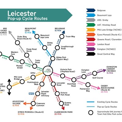
A NEW map has been produced showing Leicester’s pop-up cycle track network in the style of the classic London Underground map.
The map uses different coloured routes to set out the main cycle paths connecting key residential and employment areas of the city to the city centre, and contains both new and pop-up cycle tracks.
Around 11 miles of temporary pop-up cycle routes have been installed over the last 10 weeks as part of Leicester City Council’s Covid-19 transport recovery plan, to provide commuters with safer, wider, segregated cycle lanes an alternative to using public transport, and also to encourage more people to use sustainable forms of transport.
At the centre of the new map is Leicester’s Bike Park, at the Town Hall, which reopened on June 8 to provide safe and secure bike parking. Coloured routes on the map show the key routes to and from the city centre from places including Eyres Monsell, Aylestone Village, the Great Central Way, Hinckley Road, Groby Road, Beaumont Leys, Belgrave, Evington, Oadby Racecourse and Clarendon Park.
Each route is also marked with approximate travelling times between important locations en route, such as Leicester Royal Infirmary, Victoria Park, Braunstone Leisure Centre and the city’s outer ring road.
Last month saw an 11 per cent increase in cycling across the city compared to June 2019, with an increase of 18 per cent in cycling numbers during week commencing July 13, 2020.
Leicester deputy city mayor for environment and transportation, Cllr Adam Clarke, said: “Over the last 10 weeks we’ve created 11 miles of pop-up cycling and walking routes, as well as related pavement-widening schemes to help business to reassure customers that they can socially distance and use busy shopping areas safely.
“The work started back in March with the Key Worker Corridor, serving Leicester Royal Infirmary so that NHS staff can get to work sustainably and safely. On the back of its success, the Government has supported us with funding to roll out this vast network of schemes across the city.
“The speed at which this work has been carried out is a fantastic achievement, helping both the urgent need to tackle the Covid-19 pandemic, and our longer-term goals of getting more people to use sustainable and active transport to improve our environment and our health.”
The work forms part of the wider Leicester Covid-19 Transport Recovery Plan which was published at the start of June, setting out how the city’s transport system can best meet the challenges presented by the coronavirus pandemic and help the city’s economy to recover, as well as securing longer-term environmental benefits.
Since then, pop-up cycle routes have been installed in London Road, Aylestone Road, Saffron Lane, Hinckley Road, Beaumont Leys Lane and Abbey Park Road, along with works to widen the pavements at Belgrave’s Golden Mile, Braunstone Gate, Green Lane Road, Granby Street and Queens Road.
The plan included a commitment by City Mayor Peter Soulsby to create a mile every week of new cycling and walking routes, both by using pop-up temporary routes or bringing forward the completion date for longer-term, permanent infrastructure projects from the ongoing Connecting Leicester works.
Copies of the new map are available from the Town Hall Bike Park, or can be downloaded here.
In addition people can also put forward their suggestions for where they want to see better cycling or walking routes, by visiting http://widenmypath.com/leicester
People can also gain reward points for walking and cycling using the BetterPoints smartphone app, with extra weekly prizes to celebrate the new pop-up cycle lanes and widened footways. Download the app from the Choose How You Move website.
To Leicester Transport Recovery Plan is available to view online.
(Ends)
